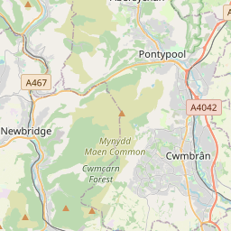


Current traffic around St Dials
The following traffic incidents and congestion for St Dials have been reported by Highways England, Traffic Scotland, Traffic Wales or Transport for London (TfL) in the last two hours:
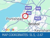
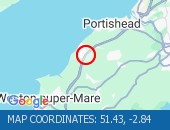
ACCIDENT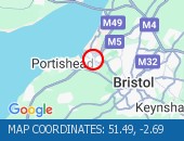 Location: The M5 northbound between junctions J19 (Portishead) and J18 (Bristol) .
Reason: Road traffic collision.
Status: Cleared.
Nearest town: 18.26 miles from St Dials.SOUTHBOUND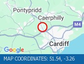 Description: A470Now clearSouthboundNantgarw to Coryton, Start time: 16/05/2025 9:00 , Expected end time: 16/05/2025 9:05, Severity: Moderate, Source: Welsh Government, Last updated: 16/05/2025 9:00
Nearest town: 11.6 miles from St Dials. CLEARED @ 10:18NORTHBOUND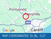 Description: A470Now clearNorthboundNantgarw, Start time: 16/05/2025 9:02 , Expected end time: 16/05/2025 9:07, Severity: Moderate, Source: Welsh Government, Last updated: 16/05/2025 9:02
Nearest town: 11.18 miles from St Dials. CLEARED @ 10:18EASTBOUND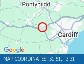 Description: M4Now clearEastboundJ33 (Cardiff) Capel Llanilltern, Start time: 16/05/2025 8:20 , Expected end time: 16/05/2025 8:25, Severity: Moderate, Source: Welsh Government, Last updated: 16/05/2025 8:20
Nearest town: 14.7 miles from St Dials. CLEARED @ 09:42NANTGARWDescription: A470NorthboundNantgarwCongestionoffslipDelay: s possible :, Start time: 16/05/2025 7:48 , Expected end time: 16/05/2025 9:48, Severity: Moderate, Source: Welsh Government, Last updated: 16/05/2025 7:48
Nearest town: 11.18 miles from St Dials. CLEARED @ 07:54NANTGARW TO CORYTONDescription: A470SouthboundNantgarw to CorytonCongestionDelay: s possible :, Start time: 16/05/2025 7:16 , Expected end time: 16/05/2025 9:16, Severity: Moderate, Source: Welsh Government, Last updated: 16/05/2025 7:16
Nearest town: 11.6 miles from St Dials. CLEARED @ 07:30J33 CAPEL LLANILLTERNDescription: M4EastboundJ33 (Cardiff) Capel LlanillternCongestionoffslipDelay: s possible :, Start time: 16/05/2025 7:19 , Expected end time: 16/05/2025 11:18, Severity: Moderate, Source: Welsh Government, Last updated: 16/05/2025 7:19
Nearest town: 14.7 miles from St Dials. CLEARED @ 07:30ST FAGANS TO M4 J33 CAPEL LLANILLTERN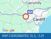 Description: A4232NorthboundSt Fagans to M4 J33 Capel LlanillternCongestionDelay: s possible :, Start time: 16/05/2025 7:19 , Expected end time: 16/05/2025 9:19, Severity: Moderate, Source: Welsh Government, Last updated: 16/05/2025 7:19
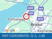
Nearest town: 14.78 miles from St Dials. CLEARED @ 07:30CONGESTION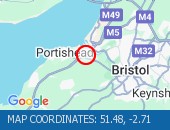 Location: The M5 northbound entry slip at junction J19 (Portishead) .
Reason: Congestion.
Status: Currently Active.
Return to normal: Normal traffic conditions are expected between 11:45 and 12:00 on 16 May 2025.
Delay: There are currently delays of 10 minutes against expected traffic.
Nearest town: 18.15 miles from St Dials.CONGESTIONLocation: The M5 northbound between junctions J20 (Nailsea) and J19 (Portishead) .
Reason: Congestion.
Status: Currently Active.
Return to normal: Normal traffic conditions are expected between 12:00 and 12:15 on 16 May 2025.
Delay: There are currently delays of 30 minutes against expected traffic.
Earlier Reason: Caused by an earlier accident.
Nearest town: 18.09 miles from St Dials.TUA'R GOGLEDDDisgrifiad: A4232Wedi clirioTuar GogleddSain Ffagan i M4 C33 Llanilltern, Amser y digwyddiad: 16/05/2025 8:26 , Amser gorffen a ragwelir: 16/05/2025 8:31, Difrifoldeb: Cymedrol, Ffynhonnell: Llywodraeth Cymru, Diweddarwyd ddiwethaf: 16/05/2025 8:26
Nearest town: 14.78 miles from St Dials. CLEARED @ 09:42WENALLT ROAD OVERBRIDGE Description: M4Both directionsWenallt Road OverbridgeRoad closedStructural inspectionsDiversions in place19/05/25-20/05/25 2000-0500 :, Start time: 19/05/2025 20:00 , End Date: 20/05/2025 5:00, Severity: Road closure, Source: Welsh Government, Last updated: 15/05/2025 7:40
Nearest town: 11.77 miles from St Dials. CLEARED @ 08:06J29 CASTLETON TO J26 MALPAS Description: M4EastboundJ29 (Cardiff) Castleton to J26 (Newport) MalpasCongestionDelay: s possible :, Start time: 16/05/2025 11:29 , Expected end time: 16/05/2025 17:29, Severity: Slight, Source: Welsh Government, Last updated: 16/05/2025 11:29
Nearest town: 4.66 miles from St Dials.
Reason: Road traffic collision.
Status: Cleared.
Nearest town: 18.26 miles from St Dials.
Nearest town: 11.6 miles from St Dials. CLEARED @ 10:18
Nearest town: 11.18 miles from St Dials. CLEARED @ 10:18
Nearest town: 14.7 miles from St Dials. CLEARED @ 09:42
Nearest town: 11.18 miles from St Dials. CLEARED @ 07:54
Nearest town: 11.6 miles from St Dials. CLEARED @ 07:30
Nearest town: 14.7 miles from St Dials. CLEARED @ 07:30
Nearest town: 14.78 miles from St Dials. CLEARED @ 07:30
Reason: Congestion.
Status: Currently Active.
Return to normal: Normal traffic conditions are expected between 11:45 and 12:00 on 16 May 2025.
Delay: There are currently delays of 10 minutes against expected traffic.
Nearest town: 18.15 miles from St Dials.
Reason: Congestion.
Status: Currently Active.
Return to normal: Normal traffic conditions are expected between 12:00 and 12:15 on 16 May 2025.
Delay: There are currently delays of 30 minutes against expected traffic.
Earlier Reason: Caused by an earlier accident.
Nearest town: 18.09 miles from St Dials.
Nearest town: 14.78 miles from St Dials. CLEARED @ 09:42
Nearest town: 11.77 miles from St Dials. CLEARED @ 08:06
Nearest town: 4.66 miles from St Dials.
There are no current incidents in this location.


 National Highways England
 Transport for London (TFL)
 Traffic Wales
 Traffic Scotland
 YOUR AD HERE