Traffic incidents
The following traffic incidents and congestion for M4 have been reported by Highways England, Traffic Scotland, Traffic Wales or Transport for London (TfL) in the last two hours:
CONGESTION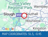 Location: The M4 westbound exit slip at junction J4 .
Reason: Congestion.
Status: Currently Active.
Return to normal: Normal traffic conditions are expected between 23:15 and 23:30 on 14 Dec 2025.
Nearest town: 1.98m from Heathrow. CLEARED @ 23:23J43 LLANDARCY TO J42 EARLSWOOD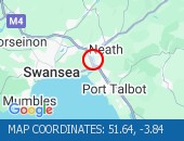 Description: M4EastboundJ43 (Neath) Llandarcy to J42 (Swansea) EarlswoodOutside laneFloodingClosed :,Start time: 15/12/2025 4:44 ,Expected end time:15/12/2025 10:43,Severity: Slight,Source: Welsh Government,Last updated: 15/12/2025 4:44
Nearest town: 0.62m from Llandarcy.
Reason: Congestion.
Status: Currently Active.
Return to normal: Normal traffic conditions are expected between 23:15 and 23:30 on 14 Dec 2025.
Nearest town: 1.98m from Heathrow. CLEARED @ 23:23
Nearest town: 0.62m from Llandarcy.
There are no current incidents in this location.


 National Highways England
 Transport for London (TFL)
 Traffic Wales
 Traffic Scotland
 YOUR AD HERE