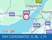
Location: eastbound between junctions J23 (Chepstow) and J22 (Avonmouth) .
Lane Closures : Lanes 1, 2 and 3 will be closed.
Due to: Roadworks are planned.
Status : Pending.
Schedule : Expect disruption everyday between 21:00 and 06:00 from 1 May 2025 to 3 May 2025.
Lanes Closed : All lanes will be closed.
Nearest town: 17.16 miles from Llanfach.
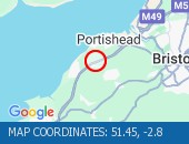
Location: northbound between junctions J20 (Nailsea) and J19 (Portishead) .
Due to: Roadworks scheme is planned.
Status : Pending.
Schedule : From 21:00 on 26 April 2025 to 06:00 on 27 April 2025.
Nearest town: 19.44 miles from Llanfach.

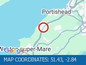
Location: northbound between junctions J20 (Nailsea) and J19 (Portishead) .
Lane Closures : Lane one will be closed.
Due to: Roadworks are planned.
Status : Pending.
Schedule : From 21:00 on 26 April 2025 to 06:00 on 27 April 2025.
Lanes Closed : There will be one of three lanes closed.
Nearest town: 19.6 miles from Llanfach.
Location: northbound between junctions J20 (Nailsea) and J19 (Portishead) .
Lane Closures : Lane one will be closed.
Due to: Roadworks are planned.
Status : Pending.
Schedule : From 21:00 on 26 April 2025 to 06:00 on 27 April 2025.
Lanes Closed : There will be one of four lanes closed.
Nearest town: 19.44 miles from Llanfach.
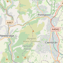
Location: northbound at junction J20 (Nailsea) .
Lane Closures : Lane one will be closed.
Due to: Emergency roadside drains works are planned.
Status : Pending.
Schedule : Expect disruption everyday between 20:00 and 04:00 from 25 April 2025 to 23 May 2025.
Schedule : Expect disruption everyday between 20:00 and 04:00 from 27 May 2025 to 22 August 2025.
Schedule : Expect disruption everyday between 20:00 and 04:00 from 26 August 2025 to 28 March 2026.
Schedule : From 20:00 on 28 March 2026 to 04:00 on 29 March 2026.
Lanes Closed : There will be one of three lanes closed.
Nearest town: 19.45 miles from Llanfach.


 National Highways England
 Transport for London (TFL)
 Traffic Wales
 Traffic Scotland
 YOUR AD HERE